

Category of Astronomical Heritage: tangible immovable
Chankillo, Peru
Format: Full Description (IAU Extended Case Study format)
Identification of the property
Country/State Party
Peru
State/Province/Region
Ancash region, Casma province, Casma district
Name
Chankillo
Geographical co-ordinates and/or UTM
803325 E, 8942566 N, UTM Zone 17S
Maps and plans,
showing boundaries of property and buffer zone
See figures below
Area of property and buffer zone
17.41254 km²
Description
Description of the property
Like many of Peru’s coastal valleys, Casma has long been an ‘oasis’ for human settlement in an otherwise inhospitable environment. The Casma-Sechin river basin runs down the western slopes of the Andes mountain range through one of the world’s driest deserts, an arid landscape of barren foothills, sandy plains, and narrow valleys that has geologically remained relatively unchanged since the Pleistocene.
Despite this extreme environment, sites such as Las Haldas, Sechin, Pampa de las Llamas-Moxeke, Chankillo, El Purgatorio, and Manchan demonstrate a long period of occupation (4500 years) from the Archaic period to the Incas, suggesting that the area has always been an important regional ceremonial center. Formative period sites in Casma are unequalled nationally in terms of their size, quality, and public architecture. It is now only the ceremonial structures that survive, generally using spaces that would not compromise maximum use of the riverside land for agriculture. The less robust residential sites and cemeteries, perhaps more closely associated with the cultivation zone along the rivers, are no longer visible.
Chankillo is a ceremonial site with complex ritual, administrative, and defensive functions found 365 km north of Lima and 15 km from the Pacific coast (Fig. 1). It is adjacent to the irrigated valley of the southern branch of the Casma/Sechin river basin, facing the rugged foothills of the western slopes of the Andes. Dozens of 14C dates, all in the range 2350-2150 cal BP, place the construction, occupation, and abandonment of Chankillo within the late Early Horizon period (500-200 BC) in central Peruvian chronology (Burger 1995).
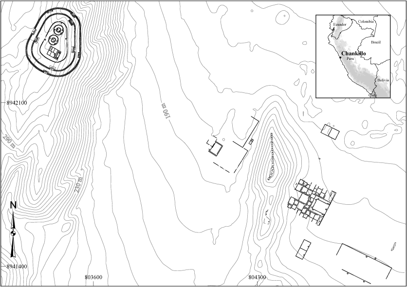
Fig. 1: Plan of Chankillo. © Iván Ghezzi
In 2008, Peru’s Ministry of Culture determined Chankillo to be a ’monumental archaeological zone‘, spread over 17.4 km² (Fig. 2). A buffer zone was not determined. This area includes archaeological evidence from various periods of occupation, but is characterized by late Early Horizon period monumental stone and mortar constructions, originally plastered and painted with ochre, tan, yellow, and white pigments, sometimes decorated with relief, graffiti, or textured with finger impressions.
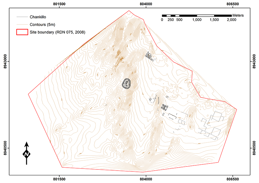
Fig. 2: The ’monumental archaeological zone‘ at Chankillo, spread over 17.4 km². © Iván Ghezzi
These constructions define three main site sectors. The most outstanding feature of Sector 1 is an oval-shaped hilltop building known as the Fortified Temple (Fig. 3). A massive construction, located strategically 180 m above the valley floor, it is composed of three central structures surrounded by concentric defensive walls. At its center, two identical buildings with circular ground plan and a rectangular building are surrounded by a platform with parapets, which serves as the innermost defensive wall as well. The twin buildings are composed of pairs of concentric circular walls with three restricted-access gates. They may have served as a last level of refuge.
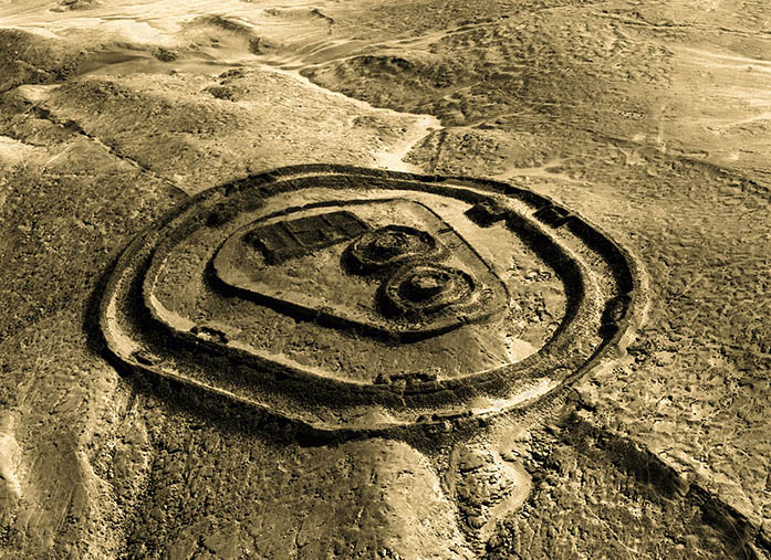
Fig. 3: Aerial view of the fortified temple at Chankillo. Photograph © Servicio Aerofotográfico Nacional, Lima
The rectangular building is a temple or palace oriented to the December solstice sunrise. Its front atrium is a U-shaped two-tiered platform with dual staircases on each level. The rooms behind it, sometimes bearing mural decoration (Fig. 4), were used for ritual and possibly elite habitation.

Fig. 4: Mural decoration in one of the rooms of the rectangular building within the fortified temple at Chankillo. © Iván Ghezzi
The walls surrounding the inner buildings and platform are massive, standing in places up to 8 m. These are complex walls, made up of several parallel wall sections with in-between fill. The wall tops were accessed through staircases spread around the perimeter at regular intervals. There were nine baffled gates, protected with parapets, top rooms hidden from outside view, false corridors, and other strategic measures. Though their defensive function has been ably questioned (Topic and Topic 1997), the available evidence indicates the main purpose of these walls was to provide protection, while regulating traffic, to the interior of the fort.
Excavations at the rectangular building within the central platform revealed the intentional destruction of its walls, pillars, and religious images, the possible looting of objects, and its entombment under a thick layer of rock and debris. It was probably due to conflict, causing the forced abandonment of the site (Ghezzi 2006).
East of the Fortified Temple are Sectors 2 and 3, a large ceremonial area with buildings, plazas, storage facilities, and the Thirteen Towers, the main feature of Sector 2 (Fig. 5B). These are a row of thirteen constructions placed along the ridge of a low hill at the center of the site, whose summit is reached by inset staircases on their north and south sides (Fig. 6). Their groundplan varies from rectangular to rhomboidal. Their size (75-125 m²) and height (2-6 m) vary widely: the northernmost towers are taller, apparently to compensate for the drop in elevation of the natural hill on which they rest. Nonetheless, they are regularly spaced: the gaps between the towers range from 4.7 to 5.1 m.
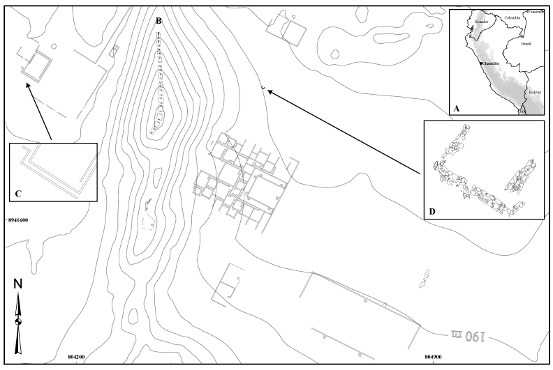
Fig. 5: Plan of the area in the vicinity of the thirteen towers. © Iván Ghezzi
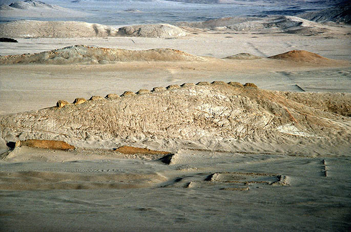
Fig. 6: The thirteen towers as seen from the fortified temple. Photograph © Iván Ghezzi
The towers were flat-topped, originally forming a smooth, ’false‘ horizon as viewed from the lower ground to the west or east. No artifacts remain on the summits, yet the staircases strongly suggest that these surfaces were occupied at special times. Ascension to the towers may have been important ritually, yet because their staircases are narrow (1.3-1.5 m wide), and their length (1.3-5.2 m) and height (2-6 m) vary in proportion to tower dimensions, several of them are too steep to climb. The importance of the concept of duality has been amply discussed for the Central Andes, and its manifestation in the dual staircases at the towers, the layout of rooms within buildings, and the use of the double step-motif in sacred architectural elements and pottery vessels at Chankillo reflect the great symbolic importance of the Thirteen Towers.
The line of towers runs north-south, although towers 11-13 are twisted around towards the south-west (Fig 5B). In addition, Towers 11-12 cover the largest area. This may suggest that Tower 13 was intentionally ’hidden‘ from some eastern viewing positions. Yet the azimuths of the gaps between the towers, which vary progressively, north to south, from approximately 90°-270° to 120°-300°, suggest something else: that the purpose of the variations in the orientation of the tower axes was to orient the gaps between the towers towards a group of buildings within a walled enclosure to the west.
The best preserved of these buildings, known as the West Observatory, is 53.6 m long, 36 m wide, and has an outer corridor running 40 m along its south side (Fig. 5C). This corridor connected a restricted doorway on the southwest side of the building with a southeast opening that directly faced the Thirteen Towers 235 m away. However, the southeast doorway, unlike every other doorway at Chankillo, did not have the typical barholds, or niches where a stone pin was firmly tied into the masonry, presumably used to attach a door. In other words, it was a doorless opening. This corridor was a unique construction that ran alongside the building, but never led into it. Its purpose was to channel movement from its restricted gateway to its doorless opening directly facing the Thirteen Towers.
Sector 3 is a public area composed of a plaza surrounded by buildings, among them a complex of interconnected rooms, corridors, and patios, with associated facilities for the serving and storage of drinks directly southeast of the Thirteen Towers (Fig. 5). A small staircase on the eastern perimeter wall is apparently the single point of access to this building’s interior, and leads into a large patio surrounded by a U-shaped platform with inset staircases that distribute traffic towards the different rooms and courtyards. The pattern of circulation suggests a complex spatial organization. Towards the interior of the building, the rooms are reduced in size, but gain in elevation and wall height, and have a more restricted control of access. This building, the adjacent plaza, and other small buildings in Sector 3 were a setting for ceremonial feasts. In several places within the plaza were found offerings of panpipes and thorny oyster (Spondylus) shells. Middens near it contain the remains of serving vessels, panpipes, and maize.
The Thirteen Towers of Chankillo have been interpreted as horizon markers for astronomical observations (Ghezzi and Ruggles 2007). From several locations around Chankillo, the towers are the dominant feature in the horizon and could be used as solar horizon markers, but two buildings are of particular interest. From the doorless opening of the West Observatory, known as west observing point, the spread of the towers along the horizon corresponds very closely to the range of movement of the rising and setting positions of the Sun over the year. This in itself argues strongly that the towers were used for solar observation. From this observing point, the southern slopes of Mucho Malo mountain, at a distance of 3 km, meet the nearer horizon (formed by the nearby hill on which the towers are constructed) just to the left of the northernmost tower (Tower 1), providing a 13th ’gap‘ of similar width to those between each pair of adjacent towers down the line. During the June solstice, the sun rises in this position (Fig. 7); conversely, during the December solstice, it rises directly to the left of the southernmost tower (Tower 13).
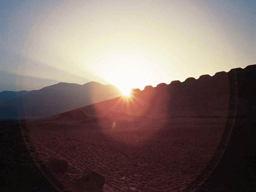
Fig. 7: June solstice sunrise viewed from the western observing point. Photograph © Iván Ghezzi
In Sector 3, there is a small, isolated structure (Fig. 5D). Only the incomplete outline of a rectangular room, 6 m wide, is preserved. Its position in relation to the towers mirrors almost exactly the west observing point: the two lie on the same east-west line, have similar elevation, and are at the same distance from the Thirteen Towers. When viewed from inside this building, the spread of the towers forms an artificial horizon as well. Like the corridor leading to the western observing point on the opposite side of the towers, we hypothesize that this room contained an eastern observing point, though its exact position cannot be known, due to poor preservation, with the same certainty as that of the western observing point. From this eastern observing point, the southernmost tower (Tower 13) would not have been visible, and the top of Tower 12 would only just have been visible (it is only partially visible now due to its ruinous condition). From here, the December solstice Sun set behind the left side of the southernmost visible tower (Tower 12), whereas the June solstice Sun sets directly to the right of the northernmost tower (Tower 1).
From each observing point, once the Sun had begun to move appreciably away from either of its extreme rising positions a few days after each solstice, the towers and gaps would have provided a means to track the progress of the Sun up and down this artificial horizon to within an accuracy of two or three days.
History and development
Chankillo was occupied in 350-100 cal BC, during the late Early Horizon period of Peruvian prehistory. Research suggests it was devoted to regulating seasonal ritual events, such as religious festivals, solar worship, and the staging of ritual or real battles, maintaining a ceremonial calendar through solar observations.
To judge from the available evidence, the entire site was built and used within a relatively short period. A unique axis of orientation and the functional interconnections between sectors of the site suggest that its layout is the result of a master design. Preliminary dendrochronological research, though unable to provide calendar dates at present, indicates that all wooden lintels used in the construction of gates and doorways are contemporaneous. Radiocarbon date ranges, though broad for this period owing to calibration, does not differentiate at all between site sectors. Finally, excavations reveal that all buildings, save for one peripheral construction, were completed and in use by the time of Chankillo’s abrupt abandonment.
No significant developments or modifications to the site are obvious from its surface, or from excavation. For example, there is no evidence that any of the lintels were ever replaced. Walls or floors were often repaired, but rooms were not remodeled, thus reinforcing the impression that Chankillo was occupied briefly, and not significantly modified in regard to its form, function, and use.
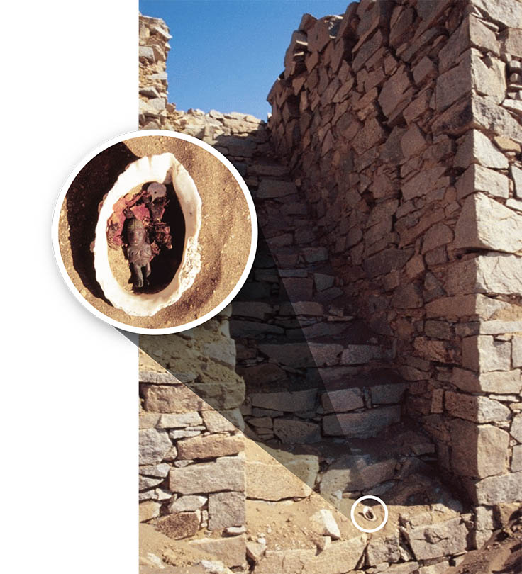
Fig. 8: Inca ‘fertility’ offering recovered from Tower 1. © Iván Ghezzi
Excavations at the Fortified Temple clearly revealed the intentional destruction of its inner temple and religious images, the possible looting of objects, and its entombment under a thick layer of rock and debris. This attempt at erasing the temple from cultural memory was probably due to a violent conflict with an outside power, which ended in the defeat of Chankillo and an abrupt abandonment of the site (Ghezzi 2006).
There is some evidence of later occupations in the form of Early to Late Intermediate period temporary habitations and human burials. However, the significance of Chankillo may have persisted for a long time in the area, as suggested by numerous graffiti of warriors on the Fortified Temple walls, Late Intermediate period figurine offerings at the gates, and, most notably, an Inca ‘fertility’ offering recovered precisely from the tower clearly associated with the date of harvest festivals in prehistoric Peru (Fig. 8). Similarly, Early to Late Intermediate period cemeteries around the Thirteen Towers and the northern periphery of the site may have taken advantage of what was thought of as sacred ground long after its abandonment.
No mention of Chankillo has been found in colonial-era documents. The earliest references belong to the second half of the 19th century, when some of the most famous explorers and naturalists of the time published accounts and drawings of the site (Squier 1877; Raimondi 1874, 1909; Middendorf 1973). Julio C. Tello, who explored the site in the 1930s, led the first archaeological investigations (Tello 1956). Other scholars published additional reports, but Fung and Pimentel, who carried out a research and conservation project, offered the most comprehensive description of Chankillo to date (Collier 1962, Fung and Pimentel 1973; Kroeber 1944; Kosok 1965; Pozorski and Pozorski 1987; Roosevelt 1935; Thompson, 1962, 1974; Topic and Topic 1978, 1997; Wilson 1995).
In 2008, by resolution RDN #075, January 15, 2008, Peru’s National Institute of Culture declared the ’Chankillo Monumental Archaeological Zone‘ a national cultural heritage site, and approved a map that establishes its protected boundaries (Fig. 2). A buffer zone was not determined. Recent encroachment on the site, through agricultural, mining, and commercial activities, highlights the urgent need for a buffer zone, which is now under consideration by the Ministry of Culture.
Justification for inscription
Comparative analysis
Peru
State/Province/Region
Ancash region, Casma province, Casma district
Name
Chankillo
Geographical co-ordinates and/or UTM
803325 E, 8942566 N, UTM Zone 17S
Maps and plans,
showing boundaries of property and buffer zone
See figures below
Area of property and buffer zone
17.41254 km²
Description
Description of the property
Like many of Peru’s coastal valleys, Casma has long been an ‘oasis’ for human settlement in an otherwise inhospitable environment. The Casma-Sechin river basin runs down the western slopes of the Andes mountain range through one of the world’s driest deserts, an arid landscape of barren foothills, sandy plains, and narrow valleys that has geologically remained relatively unchanged since the Pleistocene.
Despite this extreme environment, sites such as Las Haldas, Sechin, Pampa de las Llamas-Moxeke, Chankillo, El Purgatorio, and Manchan demonstrate a long period of occupation (4500 years) from the Archaic period to the Incas, suggesting that the area has always been an important regional ceremonial center. Formative period sites in Casma are unequalled nationally in terms of their size, quality, and public architecture. It is now only the ceremonial structures that survive, generally using spaces that would not compromise maximum use of the riverside land for agriculture. The less robust residential sites and cemeteries, perhaps more closely associated with the cultivation zone along the rivers, are no longer visible.
Chankillo is a ceremonial site with complex ritual, administrative, and defensive functions found 365 km north of Lima and 15 km from the Pacific coast (Fig. 1). It is adjacent to the irrigated valley of the southern branch of the Casma/Sechin river basin, facing the rugged foothills of the western slopes of the Andes. Dozens of 14C dates, all in the range 2350-2150 cal BP, place the construction, occupation, and abandonment of Chankillo within the late Early Horizon period (500-200 BC) in central Peruvian chronology (Burger 1995).
Fig. 1: Plan of Chankillo. © Iván Ghezzi
In 2008, Peru’s Ministry of Culture determined Chankillo to be a ’monumental archaeological zone‘, spread over 17.4 km² (Fig. 2). A buffer zone was not determined. This area includes archaeological evidence from various periods of occupation, but is characterized by late Early Horizon period monumental stone and mortar constructions, originally plastered and painted with ochre, tan, yellow, and white pigments, sometimes decorated with relief, graffiti, or textured with finger impressions.
Fig. 2: The ’monumental archaeological zone‘ at Chankillo, spread over 17.4 km². © Iván Ghezzi
These constructions define three main site sectors. The most outstanding feature of Sector 1 is an oval-shaped hilltop building known as the Fortified Temple (Fig. 3). A massive construction, located strategically 180 m above the valley floor, it is composed of three central structures surrounded by concentric defensive walls. At its center, two identical buildings with circular ground plan and a rectangular building are surrounded by a platform with parapets, which serves as the innermost defensive wall as well. The twin buildings are composed of pairs of concentric circular walls with three restricted-access gates. They may have served as a last level of refuge.
Fig. 3: Aerial view of the fortified temple at Chankillo. Photograph © Servicio Aerofotográfico Nacional, Lima
The rectangular building is a temple or palace oriented to the December solstice sunrise. Its front atrium is a U-shaped two-tiered platform with dual staircases on each level. The rooms behind it, sometimes bearing mural decoration (Fig. 4), were used for ritual and possibly elite habitation.
Fig. 4: Mural decoration in one of the rooms of the rectangular building within the fortified temple at Chankillo. © Iván Ghezzi
The walls surrounding the inner buildings and platform are massive, standing in places up to 8 m. These are complex walls, made up of several parallel wall sections with in-between fill. The wall tops were accessed through staircases spread around the perimeter at regular intervals. There were nine baffled gates, protected with parapets, top rooms hidden from outside view, false corridors, and other strategic measures. Though their defensive function has been ably questioned (Topic and Topic 1997), the available evidence indicates the main purpose of these walls was to provide protection, while regulating traffic, to the interior of the fort.
Excavations at the rectangular building within the central platform revealed the intentional destruction of its walls, pillars, and religious images, the possible looting of objects, and its entombment under a thick layer of rock and debris. It was probably due to conflict, causing the forced abandonment of the site (Ghezzi 2006).
East of the Fortified Temple are Sectors 2 and 3, a large ceremonial area with buildings, plazas, storage facilities, and the Thirteen Towers, the main feature of Sector 2 (Fig. 5B). These are a row of thirteen constructions placed along the ridge of a low hill at the center of the site, whose summit is reached by inset staircases on their north and south sides (Fig. 6). Their groundplan varies from rectangular to rhomboidal. Their size (75-125 m²) and height (2-6 m) vary widely: the northernmost towers are taller, apparently to compensate for the drop in elevation of the natural hill on which they rest. Nonetheless, they are regularly spaced: the gaps between the towers range from 4.7 to 5.1 m.
Fig. 5: Plan of the area in the vicinity of the thirteen towers. © Iván Ghezzi
Fig. 6: The thirteen towers as seen from the fortified temple. Photograph © Iván Ghezzi
The towers were flat-topped, originally forming a smooth, ’false‘ horizon as viewed from the lower ground to the west or east. No artifacts remain on the summits, yet the staircases strongly suggest that these surfaces were occupied at special times. Ascension to the towers may have been important ritually, yet because their staircases are narrow (1.3-1.5 m wide), and their length (1.3-5.2 m) and height (2-6 m) vary in proportion to tower dimensions, several of them are too steep to climb. The importance of the concept of duality has been amply discussed for the Central Andes, and its manifestation in the dual staircases at the towers, the layout of rooms within buildings, and the use of the double step-motif in sacred architectural elements and pottery vessels at Chankillo reflect the great symbolic importance of the Thirteen Towers.
The line of towers runs north-south, although towers 11-13 are twisted around towards the south-west (Fig 5B). In addition, Towers 11-12 cover the largest area. This may suggest that Tower 13 was intentionally ’hidden‘ from some eastern viewing positions. Yet the azimuths of the gaps between the towers, which vary progressively, north to south, from approximately 90°-270° to 120°-300°, suggest something else: that the purpose of the variations in the orientation of the tower axes was to orient the gaps between the towers towards a group of buildings within a walled enclosure to the west.
The best preserved of these buildings, known as the West Observatory, is 53.6 m long, 36 m wide, and has an outer corridor running 40 m along its south side (Fig. 5C). This corridor connected a restricted doorway on the southwest side of the building with a southeast opening that directly faced the Thirteen Towers 235 m away. However, the southeast doorway, unlike every other doorway at Chankillo, did not have the typical barholds, or niches where a stone pin was firmly tied into the masonry, presumably used to attach a door. In other words, it was a doorless opening. This corridor was a unique construction that ran alongside the building, but never led into it. Its purpose was to channel movement from its restricted gateway to its doorless opening directly facing the Thirteen Towers.
Sector 3 is a public area composed of a plaza surrounded by buildings, among them a complex of interconnected rooms, corridors, and patios, with associated facilities for the serving and storage of drinks directly southeast of the Thirteen Towers (Fig. 5). A small staircase on the eastern perimeter wall is apparently the single point of access to this building’s interior, and leads into a large patio surrounded by a U-shaped platform with inset staircases that distribute traffic towards the different rooms and courtyards. The pattern of circulation suggests a complex spatial organization. Towards the interior of the building, the rooms are reduced in size, but gain in elevation and wall height, and have a more restricted control of access. This building, the adjacent plaza, and other small buildings in Sector 3 were a setting for ceremonial feasts. In several places within the plaza were found offerings of panpipes and thorny oyster (Spondylus) shells. Middens near it contain the remains of serving vessels, panpipes, and maize.
The Thirteen Towers of Chankillo have been interpreted as horizon markers for astronomical observations (Ghezzi and Ruggles 2007). From several locations around Chankillo, the towers are the dominant feature in the horizon and could be used as solar horizon markers, but two buildings are of particular interest. From the doorless opening of the West Observatory, known as west observing point, the spread of the towers along the horizon corresponds very closely to the range of movement of the rising and setting positions of the Sun over the year. This in itself argues strongly that the towers were used for solar observation. From this observing point, the southern slopes of Mucho Malo mountain, at a distance of 3 km, meet the nearer horizon (formed by the nearby hill on which the towers are constructed) just to the left of the northernmost tower (Tower 1), providing a 13th ’gap‘ of similar width to those between each pair of adjacent towers down the line. During the June solstice, the sun rises in this position (Fig. 7); conversely, during the December solstice, it rises directly to the left of the southernmost tower (Tower 13).
Fig. 7: June solstice sunrise viewed from the western observing point. Photograph © Iván Ghezzi
In Sector 3, there is a small, isolated structure (Fig. 5D). Only the incomplete outline of a rectangular room, 6 m wide, is preserved. Its position in relation to the towers mirrors almost exactly the west observing point: the two lie on the same east-west line, have similar elevation, and are at the same distance from the Thirteen Towers. When viewed from inside this building, the spread of the towers forms an artificial horizon as well. Like the corridor leading to the western observing point on the opposite side of the towers, we hypothesize that this room contained an eastern observing point, though its exact position cannot be known, due to poor preservation, with the same certainty as that of the western observing point. From this eastern observing point, the southernmost tower (Tower 13) would not have been visible, and the top of Tower 12 would only just have been visible (it is only partially visible now due to its ruinous condition). From here, the December solstice Sun set behind the left side of the southernmost visible tower (Tower 12), whereas the June solstice Sun sets directly to the right of the northernmost tower (Tower 1).
From each observing point, once the Sun had begun to move appreciably away from either of its extreme rising positions a few days after each solstice, the towers and gaps would have provided a means to track the progress of the Sun up and down this artificial horizon to within an accuracy of two or three days.
History and development
Chankillo was occupied in 350-100 cal BC, during the late Early Horizon period of Peruvian prehistory. Research suggests it was devoted to regulating seasonal ritual events, such as religious festivals, solar worship, and the staging of ritual or real battles, maintaining a ceremonial calendar through solar observations.
To judge from the available evidence, the entire site was built and used within a relatively short period. A unique axis of orientation and the functional interconnections between sectors of the site suggest that its layout is the result of a master design. Preliminary dendrochronological research, though unable to provide calendar dates at present, indicates that all wooden lintels used in the construction of gates and doorways are contemporaneous. Radiocarbon date ranges, though broad for this period owing to calibration, does not differentiate at all between site sectors. Finally, excavations reveal that all buildings, save for one peripheral construction, were completed and in use by the time of Chankillo’s abrupt abandonment.
No significant developments or modifications to the site are obvious from its surface, or from excavation. For example, there is no evidence that any of the lintels were ever replaced. Walls or floors were often repaired, but rooms were not remodeled, thus reinforcing the impression that Chankillo was occupied briefly, and not significantly modified in regard to its form, function, and use.
Fig. 8: Inca ‘fertility’ offering recovered from Tower 1. © Iván Ghezzi
Excavations at the Fortified Temple clearly revealed the intentional destruction of its inner temple and religious images, the possible looting of objects, and its entombment under a thick layer of rock and debris. This attempt at erasing the temple from cultural memory was probably due to a violent conflict with an outside power, which ended in the defeat of Chankillo and an abrupt abandonment of the site (Ghezzi 2006).
There is some evidence of later occupations in the form of Early to Late Intermediate period temporary habitations and human burials. However, the significance of Chankillo may have persisted for a long time in the area, as suggested by numerous graffiti of warriors on the Fortified Temple walls, Late Intermediate period figurine offerings at the gates, and, most notably, an Inca ‘fertility’ offering recovered precisely from the tower clearly associated with the date of harvest festivals in prehistoric Peru (Fig. 8). Similarly, Early to Late Intermediate period cemeteries around the Thirteen Towers and the northern periphery of the site may have taken advantage of what was thought of as sacred ground long after its abandonment.
No mention of Chankillo has been found in colonial-era documents. The earliest references belong to the second half of the 19th century, when some of the most famous explorers and naturalists of the time published accounts and drawings of the site (Squier 1877; Raimondi 1874, 1909; Middendorf 1973). Julio C. Tello, who explored the site in the 1930s, led the first archaeological investigations (Tello 1956). Other scholars published additional reports, but Fung and Pimentel, who carried out a research and conservation project, offered the most comprehensive description of Chankillo to date (Collier 1962, Fung and Pimentel 1973; Kroeber 1944; Kosok 1965; Pozorski and Pozorski 1987; Roosevelt 1935; Thompson, 1962, 1974; Topic and Topic 1978, 1997; Wilson 1995).
In 2008, by resolution RDN #075, January 15, 2008, Peru’s National Institute of Culture declared the ’Chankillo Monumental Archaeological Zone‘ a national cultural heritage site, and approved a map that establishes its protected boundaries (Fig. 2). A buffer zone was not determined. Recent encroachment on the site, through agricultural, mining, and commercial activities, highlights the urgent need for a buffer zone, which is now under consideration by the Ministry of Culture.
Justification for inscription
Comparative analysis
Chankillo was occupied in 350-100 cal BC, during the late Early Horizon period of Peruvian prehistory. Research suggests it was devoted to regulating seasonal ritual events, such as religious festivals, solar worship, and the staging of ritual or real battles, maintaining a ceremonial calendar through solar observations.
To judge from the available evidence, the entire site was built and used within a relatively short period. A unique axis of orientation and the functional interconnections between sectors of the site suggest that its layout is the result of a master design. Preliminary dendrochronological research, though unable to provide calendar dates at present, indicates that all wooden lintels used in the construction of gates and doorways are contemporaneous. Radiocarbon date ranges, though broad for this period owing to calibration, does not differentiate at all between site sectors. Finally, excavations reveal that all buildings, save for one peripheral construction, were completed and in use by the time of Chankillo’s abrupt abandonment.
No significant developments or modifications to the site are obvious from its surface, or from excavation. For example, there is no evidence that any of the lintels were ever replaced. Walls or floors were often repaired, but rooms were not remodeled, thus reinforcing the impression that Chankillo was occupied briefly, and not significantly modified in regard to its form, function, and use.
Fig. 8: Inca ‘fertility’ offering recovered from Tower 1. © Iván Ghezzi
Excavations at the Fortified Temple clearly revealed the intentional destruction of its inner temple and religious images, the possible looting of objects, and its entombment under a thick layer of rock and debris. This attempt at erasing the temple from cultural memory was probably due to a violent conflict with an outside power, which ended in the defeat of Chankillo and an abrupt abandonment of the site (Ghezzi 2006).
There is some evidence of later occupations in the form of Early to Late Intermediate period temporary habitations and human burials. However, the significance of Chankillo may have persisted for a long time in the area, as suggested by numerous graffiti of warriors on the Fortified Temple walls, Late Intermediate period figurine offerings at the gates, and, most notably, an Inca ‘fertility’ offering recovered precisely from the tower clearly associated with the date of harvest festivals in prehistoric Peru (Fig. 8). Similarly, Early to Late Intermediate period cemeteries around the Thirteen Towers and the northern periphery of the site may have taken advantage of what was thought of as sacred ground long after its abandonment.
No mention of Chankillo has been found in colonial-era documents. The earliest references belong to the second half of the 19th century, when some of the most famous explorers and naturalists of the time published accounts and drawings of the site (Squier 1877; Raimondi 1874, 1909; Middendorf 1973). Julio C. Tello, who explored the site in the 1930s, led the first archaeological investigations (Tello 1956). Other scholars published additional reports, but Fung and Pimentel, who carried out a research and conservation project, offered the most comprehensive description of Chankillo to date (Collier 1962, Fung and Pimentel 1973; Kroeber 1944; Kosok 1965; Pozorski and Pozorski 1987; Roosevelt 1935; Thompson, 1962, 1974; Topic and Topic 1978, 1997; Wilson 1995).
In 2008, by resolution RDN #075, January 15, 2008, Peru’s National Institute of Culture declared the ’Chankillo Monumental Archaeological Zone‘ a national cultural heritage site, and approved a map that establishes its protected boundaries (Fig. 2). A buffer zone was not determined. Recent encroachment on the site, through agricultural, mining, and commercial activities, highlights the urgent need for a buffer zone, which is now under consideration by the Ministry of Culture.