
Category of Astronomical Heritage: tangible immovable
Viña del Cerro, Chile
Format: Short Description (ICOMOS-IAU Case Study format)
Presentation
Geographical position
Tierra Amarilla, III Atacama Region, northern Chile.
Location
Latitude 27° 54′ 9″ S, longitude 70° 1′ 51″ W. Elevation 1090m above mean sea level.
General description

Fig. 1. Location of Viña del Cerro. Drawing by Ricardo Moyano
Viña del Cerro is a Diaguita-Inka metallurgical centre dating to approximately 1400 AD. The site is located in the middle of the Copiapó river valley, or Camasquil, on a rocky hill at the foot of the Calquis Mountain, near the ancient Indian town of Painegue.
Brief inventory
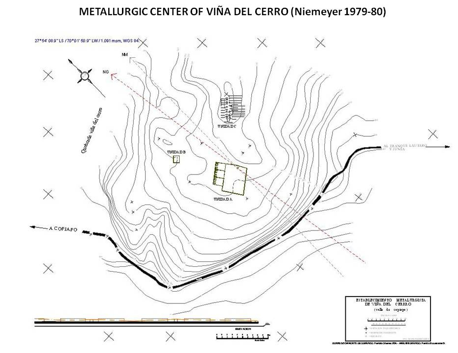
Fig. 2. See text. Drawing by Ricardo Moyano
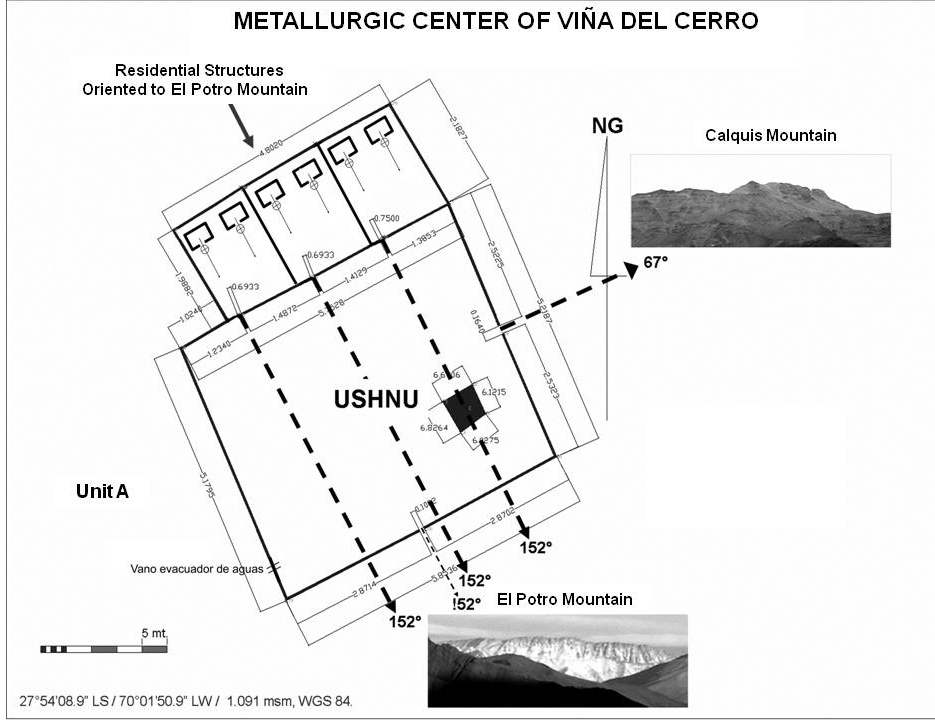
Fig. 3. See text. Drawing by Ricardo Moyano
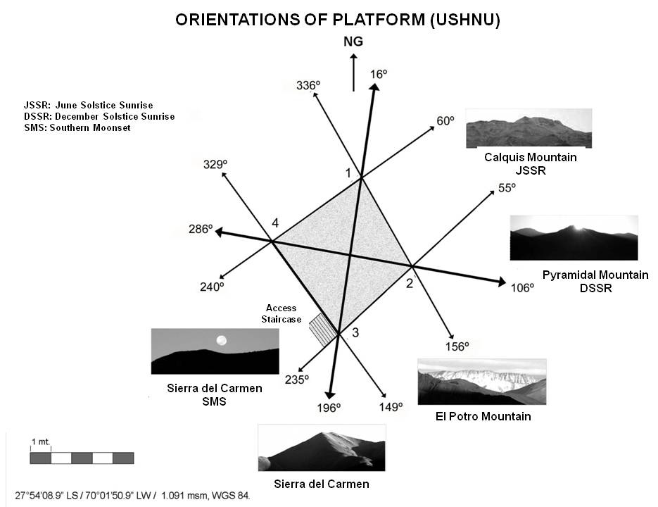
Fig. 4. See text. Drawing by Ricardo Moyano
The site is composed of four well-defined architectural units: a group of huayras (founding ovens), a control unit, a water-provisions construction, and a large plaza or kancha (see Fig. 2). The kancha or unit A, which is located on a large flat section of a rocky hill, is an area of 58.5 × 52 m constructed of mud, stone and adobe. It is composed of two architectural units: the camp and the ushnu platform. The platform is located on the eastern corner of the large plaza or kancha. It is trapezoidal in form, with a 6 m wall of mud and stone. The platform has seven steps that are 1.4 m wide, located on the east side of the south wall.
The access gates to the residential structures and the kancha are oriented towards the summits of two prominent mountains, Potro mountain in the south-east and Calquis Mountain to the north-east (Fig. 3). The ushnu ’s walls and diagonals are also aligned on these mountain peaks, together with the positions of sunrise on the two solstices (line segments 4-1 and 4-2 in Fig. 4. These and other alignments suggest that the platform that was part of the ushnu, and the access doors of the kancha and other structures, could have served for the creation and adjustment of a solar horizon calendar using specific mountains in the local landscape as reference points.
History
Tierra Amarilla, III Atacama Region, northern Chile.
Location
Latitude 27° 54′ 9″ S, longitude 70° 1′ 51″ W. Elevation 1090m above mean sea level.
General description
Fig. 1. Location of Viña del Cerro. Drawing by Ricardo Moyano
Viña del Cerro is a Diaguita-Inka metallurgical centre dating to approximately 1400 AD. The site is located in the middle of the Copiapó river valley, or Camasquil, on a rocky hill at the foot of the Calquis Mountain, near the ancient Indian town of Painegue.
Brief inventory
Fig. 2. See text. Drawing by Ricardo Moyano
Fig. 3. See text. Drawing by Ricardo Moyano
Fig. 4. See text. Drawing by Ricardo Moyano
The site is composed of four well-defined architectural units: a group of huayras (founding ovens), a control unit, a water-provisions construction, and a large plaza or kancha (see Fig. 2). The kancha or unit A, which is located on a large flat section of a rocky hill, is an area of 58.5 × 52 m constructed of mud, stone and adobe. It is composed of two architectural units: the camp and the ushnu platform. The platform is located on the eastern corner of the large plaza or kancha. It is trapezoidal in form, with a 6 m wall of mud and stone. The platform has seven steps that are 1.4 m wide, located on the east side of the south wall.
The access gates to the residential structures and the kancha are oriented towards the summits of two prominent mountains, Potro mountain in the south-east and Calquis Mountain to the north-east (Fig. 3). The ushnu ’s walls and diagonals are also aligned on these mountain peaks, together with the positions of sunrise on the two solstices (line segments 4-1 and 4-2 in Fig. 4. These and other alignments suggest that the platform that was part of the ushnu, and the access doors of the kancha and other structures, could have served for the creation and adjustment of a solar horizon calendar using specific mountains in the local landscape as reference points.
History
Fig. 2. See text. Drawing by Ricardo Moyano
Fig. 3. See text. Drawing by Ricardo Moyano
Fig. 4. See text. Drawing by Ricardo Moyano
The site is composed of four well-defined architectural units: a group of huayras (founding ovens), a control unit, a water-provisions construction, and a large plaza or kancha (see Fig. 2). The kancha or unit A, which is located on a large flat section of a rocky hill, is an area of 58.5 × 52 m constructed of mud, stone and adobe. It is composed of two architectural units: the camp and the ushnu platform. The platform is located on the eastern corner of the large plaza or kancha. It is trapezoidal in form, with a 6 m wall of mud and stone. The platform has seven steps that are 1.4 m wide, located on the east side of the south wall.
The access gates to the residential structures and the kancha are oriented towards the summits of two prominent mountains, Potro mountain in the south-east and Calquis Mountain to the north-east (Fig. 3). The ushnu ’s walls and diagonals are also aligned on these mountain peaks, together with the positions of sunrise on the two solstices (line segments 4-1 and 4-2 in Fig. 4. These and other alignments suggest that the platform that was part of the ushnu, and the access doors of the kancha and other structures, could have served for the creation and adjustment of a solar horizon calendar using specific mountains in the local landscape as reference points.