

Category of Astronomical Heritage: tangible immovable
Astronomical timing of irrigation in Oman: General description
Format: Full Description (IAU Extended Case Study format)
Identification of the property
Country/State Party
Sultanate of Oman
State/Province/Region
Northern Oman
Geographical co-ordinates and/or UTM
The area of Northern Oman containing falaj irrigation systems extends from 55° 30′ E to 59° 55′ E and from 22° 0′ N to 25° 0′ N.
Maps and plans,
showing boundaries of property and buffer zone
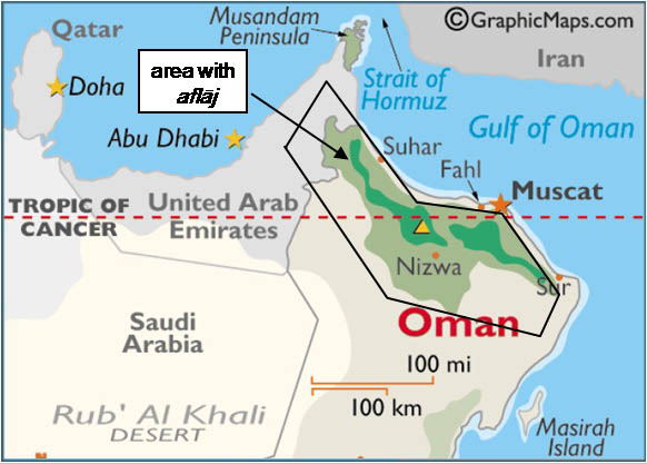
Fig. 1. Area of Oman with aflāj. Base map from worldatlas. Reproduced by permission.
Fig. 1 shows the rough outline of the area in which the sun and stars were (and in some cases still are) used for timing irrigation water. This includes the five areas listed in the nomination file for the Aflāj Irrigation Systems of Oman World Heritage Site. Villages where detailed information has been collected and stars used identified are shown in Fig. 2.
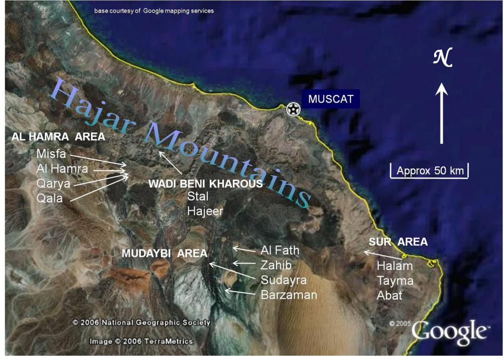
Fig. 2. Settlements where the current and past use of stars for timing irrigation water has been studied.
Description
Description of the property
The core intangible heritage is a practice (or, rather, a set of practices) of using the sun or stars to tell the time for the division of water shares from traditional irrigation systems called aflāj (the singular is falaj).
The property comprises material attributes linked to these practices. Such material can be classified into three main types:
- Sundials. These generally comprise a vertical pole and lines on the ground demarcating time intervals defined by the movement of the shadow of the tip of the pole.
- Foresights for stellar observations. These may be natural (e.g. a marker on the horizon) or man-made (e.g. a mosque wall) against which the appearance or disappearance of a star can be timed as seen from a fixed observing point.
- Observing points for watching stars. These may be marked or unmarked, although the latter are culturally acknowledged as part of the astronomical timing ‘system’. Marked observing points are generally used in conjunction with man-made foresights. In the Mudaybi area (Zahib and Al Fath), indicator stars are watched from marks on walls, rising or setting above/below a horizontal marker, often the top of a wall.
The property includes:
- The whole area with falaj irrigation systems. Most of these would have used the sun and stars for timing water shares, the exceptions being a few in the mountains that used the water clock.
- Individual villages known to be using the sun and stars in, say, 2007.
- Individual villages where details of star use have been collected.
For (2) and (3), see the location maps and Table 1. In all the settlements listed in the Table, the great majority of stars used or formerly used have been identified. In each case, the use of the sundial either continues or stopped at the same time as the use of stars. In many other villages in Oman, the sundial is still used even though people stopped using stars around 1970.
Table 1: Settlements where the use of stars in timing water shares has been documented in detail.Area Settlement Stars Sun Method of stargazing Al Hamra Al Hamra stopped c 1968 stopped c 1968 natural horizon, rising Misfat-Al-Abryeen stopped c 1970 stopped c 1970 natural horizon, rising Qarya Beni Subh in use in use natural horizon, rising Mudaybi Barzaman in use in use local horizon (wall), rising Sudayra stopped c 1970 in use local horizon (tops of trees), rising Zahib in use in use complex markers + buildings Al Fath stopped 2011 stopped 2011 complex markers + buildings Wadi Beni Kharus Stal in use by a few in use natural horizon, rising Hajeer in use by a few in use natural horizon, rising Sur Halam in use in use natural horizon, setting Tayma in use in use natural horizon, setting Abat in use in use natural horizon, setting
Examples follow from a selection of those villages studied in some detail. There are many more with sundials.
Qarya Beni Subh
Fig. 3. The sundial in Qarya Beni Subh. Photograph: Harriet Nash
Sundial comprising:
- Pole, lines, metal studs, stones or other items used as personal markers, tree for shade (see Fig. 3)
Stars:
- Foresight: natural horizon to east (see Fig. 4)
- Observing points: 3 official observing points
Fig. 4. Horizon for watching stars in Qarya Beni Subh from one of the three official observing locations. Photograph: Harriet Nash
Between the main falaj stars Vega (α Lyrae) and Deneb (α Cygni), there are three athars with four official dividers (i.e. stars named as dividers) and one unofficial divider, none of which coincides with the athar divisions. It is not known why these particular stars were selected: possibly there are no alternative easily recognised stars visible from the observation point; possibly the selection was based on actual divisions of water ownership, which may not coincide with athar divisions. This serves to illustrate just how many stars must be known and that the system will only survive as long as the official stargazer remains to resolve any disputes among farmers.
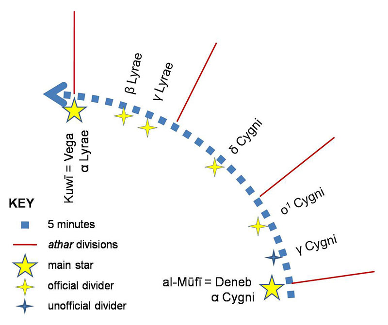
Fig. 5. Example of divisions of water share by athar and stars in Qarya Beni Subh. Drawing: Harriet Nash
Barzaman
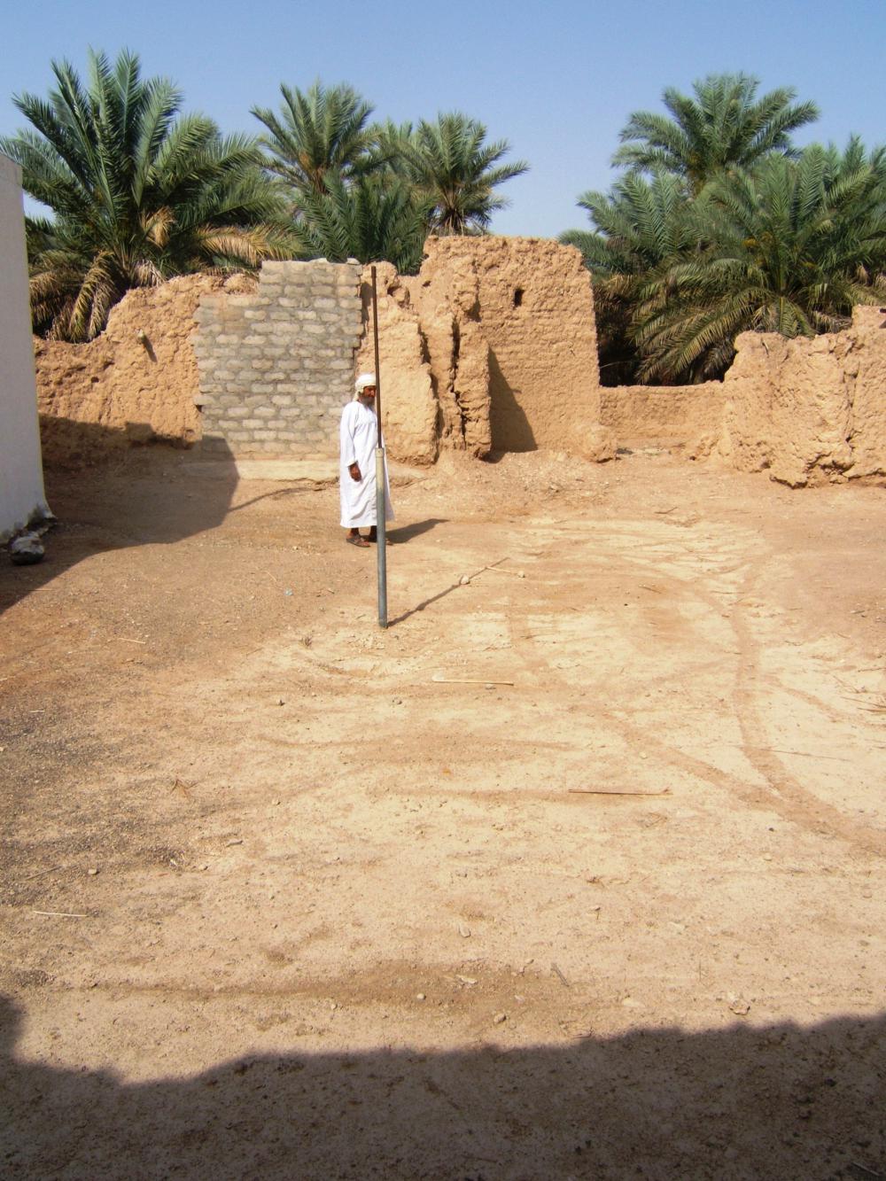
Fig. 6. The sundial in Barzaman. Photograph: Harriet Nash
Sundial comprising:
- Pole, lines scored in ground, walls of adjacent buildings, personal markers (see Fig. 6)
Stars:
- Foresight: 2 walls (one used before c. 1970 and that used now). For the latter (see Fig. 7)
- Observing points: stones in ground; Steps of mosque to wait one’s turn
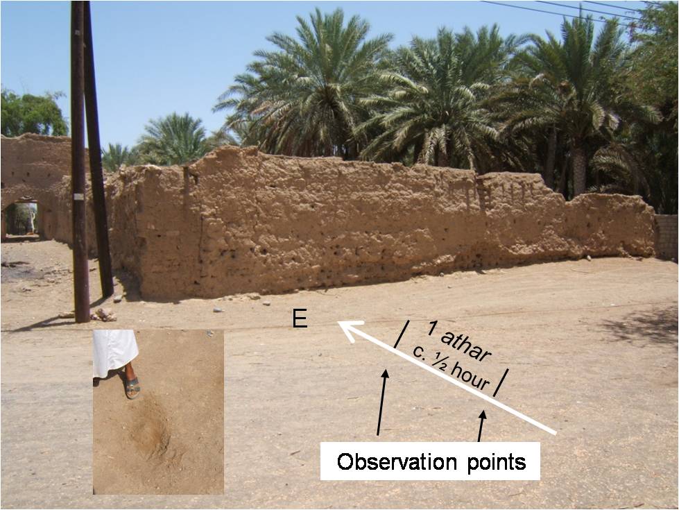
Fig. 7. Wall for watching stars in Barzaman. Inset: A stone marking an observation point. Photographs and annotations: Harriet Nash
Zahib
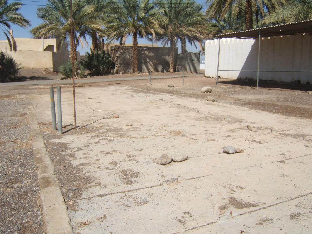
Fig. 8. The sundial in Zahib. Photograph: Harriet Nash
Sundial comprising:
- Pole, lines scored in concrete, shelter from sun, stones as personal markers (see Fig. 8)
Stars:
- Foresights: tops of walls, wooden post attached to wall
- Observing points: numerous marks on walls (see Fig. 9)
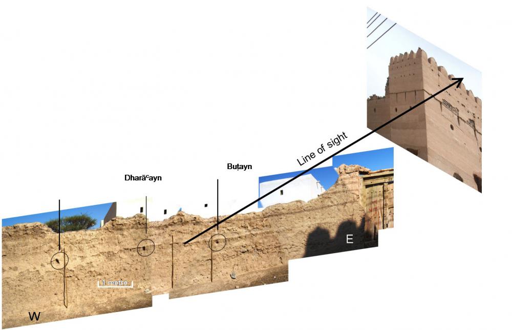
Fig. 9. Example of star observing point and foresights in Zahib. Photographs and annotations: Harriet Nash
Al Fath
Fig. 10. The sundial in Al Fath. Photograph: Harriet Nash
Sundial comprising:
- Pole, lines scored in ground, personal markers (see Fig. 10)
Stars:
- Foresights: tops of walls (mosque buildings and a tower)
- Observing points: numerous marks on walls; stones on ground (see Figs 11 & 12)
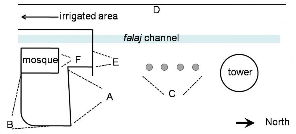
Fig. 11. Layout of star “clock” in Al Fath. A–F are observing points. Drawing: Harriet Nash
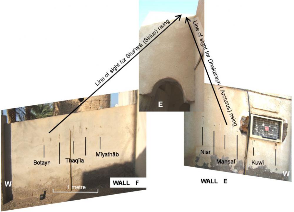
Fig. 12. Example of observing points and foresights in Al Fath. The names of stars between marks on the wall relate to the main falaj stars rising above the horizon when observing Sirius or Arcturus. Photographs and annotations: Harriet Nash
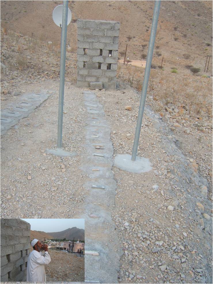
Fig. 13. The sundial in Abaat, with use of conch shell. Photographs: Harriet Nash
There are also portable artefacts relating to this practice, notably the use of a conch shell to inform farmers at a distance from a sundial that the time has come to take their water. This has been attested at two villages, Tayma and Abaat (see Fig. 13) near the town of Sur, in the east of the region.
Other sundials
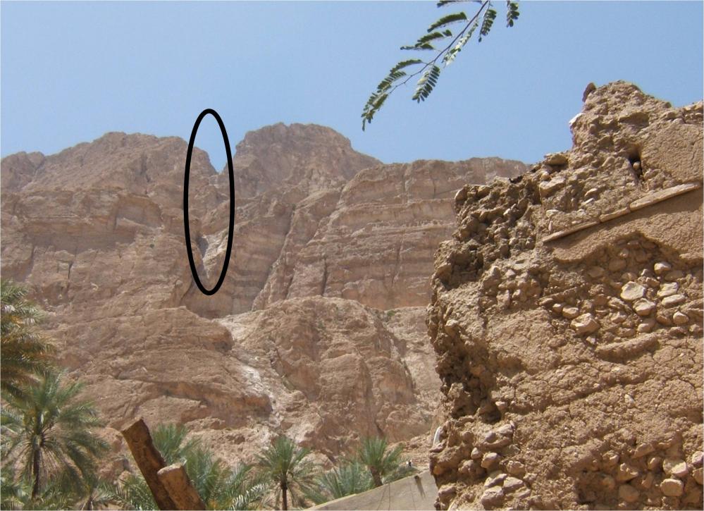
Fig. 14. Part of the “sundial” in Halam, where natural features of the landscape are used. Photograph: Harriet Nash
Fig. 15. Studious use of personal markers (date palm fronds) at a sundial in the town of Adam (approximately 60km west of Barzaman). Photograph: Harriet Nash
Other observing points for watching stars
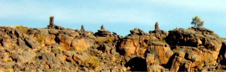
Fig. 16. Horizon formerly used for watching stars in Misfat-Al-Abryeen. Towers were built as foresights for some of the main stars, apparently to assist people with poor eyesight. Photograph: Harriet Nash
History and development
The practice of using the sun and stars for timing water shares was once widespread in semi-arid and arid areas of the Middle East and Central Asia—the heartland of falaj development. The history of falaj development is relatively well documented: they date from at least 1000 BC (e.g. al-Tikriti 2002), before Oman was controlled by the Persian Achaemenids (c 6th Century BC).
The use of sun and stars is not so well documented, but it is possible that it goes back as long as the falaj systems in communities where divisions of shares less than about 6 hours each was needed. Their use in Iran has been documented (Nash et al. 2012), and it is likely that they were used in Afghanistan and elsewhere in the region. In Iran, their use stopped in about 1960. In Oman, many communities also stopped using them when wristwatches became widely available in the late 1960s-early 1970s. However, the sun is still widely used and in a few places, where the community prefers to continue with tradition and where light and dust pollution are not too severe, the use of stars also continues.
Many of the star names are pre-Islamic, and the practitioners have no knowledge of the stellar Stations of the Moon.
Justification for inscription
Integrity and/or authenticity
Authenticity
The authenticity of the astronomical timing system is demonstrated by:
- Use and function. The practice of timing water shares by astronomical means is untouched by modern influences outside the community. The use and function is dependent on the falaj irrigation systems, which have not changed in thousands of years.
- Traditions, techniques and management systems. The tradition has been passed down from generation to generation. There may have been historical changes in the form of the sundials and in the particular stars used and the method of watching them, but there have been practically no changes due to outside influences in modern times. This is demonstrated by the lack of knowledge in one settlement of the method, stars and star names used in nearby villages.
- Location and setting. The practice was limited to the heartland of falaj/qanat development and use. Since the ready availability of wristwatches, it has become confined to Oman.
- Language. In Oman, the letter jeem is almost invariably pronounced as a hard g. However, the star gazers use a soft jeem for the word najam for star, and for some star names. This indicates that some aspects of this practice could have originated outside Oman.
- Spirit and feeling. Villagers’ strong sense of tradition ensures that the continued use of these practices results in the fair distribution of water and the avoidance of disputes. Over the generations they have contributed to the cohesion of the community and Omanis consider the falaj systems as a whole to be an important part of their national identity.
Integrity
Since these practices are handed down orally, the documents describing them are mainly based on interviews with village elders and farmers and first-hand observation by ethnographers, mostly during the last ten years. One written document has been found describing the star system used in the town of Al Hamra, on the southern edge of the Jebel Akhdar mountains; another document is an illustration of the star cycle in the town of Mudayrib. See Nash and Agius (2011).
Criteria under which inscription might be proposed
-
Criterion (iii). The material evidence relating to the astronomical timing of irrigation in Oman bears testimony to a unique cultural tradition part of which (mainly to do with sun observations) is still living but the remainder of which (including nearly all the practices relating to star observations) has disappeared.
-
Other criteria. Five falaj systems were inscribed in 2006 under criterion (v) and the ICOMOS evaluation (see p.51 in the nomination file) recognises that criteria (ii) and (iv) might also be justified on the basis of further information.
Suggested statement of OUV
The use of observations of stars for timing shares of irrigation water in Oman bears outstanding testimony to the way in which observations and understanding of the celestial bodies can help human communities adapt to and survive in harsh environments. This practice demonstrates a direct cultural connection between subsistence economy and the dark night sky that may well be unique in surviving almost to the present day, and is still not quite extinct. Related practices of solar observation that apply the same astronomical system of time apportionment during daylight hours continue in a number of communities, perhaps as many as a hundred. By continuing uninterrupted for hundreds, if not thousands, of years, the system in Oman has become perhaps the only surviving example of practices relating astronomical timing to subsistence economy that in all probability were once widespread.
State of conservation and factors affecting the property
Present state of conservation
There are conservation issues relating both to the intangible practice itself and to the material associations (human constructions and natural landscape) used in a few places.
The use of stars is almost extinct and is unlikely to last more than a decade or so. As the older generation dies, and younger people are not willing to learn the system thoroughly, there will be no one to check correct usage and people will change to using watches. In addition, the continued erosion of dark skies by light pollution is making it increasingly difficult to undertake the necessary stellar observations.
The buildings comprising the star clock in Al Fath are still in good condition.
In Zahib the buildings are still used, and in fair condition, but one wall, belonging to a private individual, was rebuilt a few years ago and the markers were not replaced. Watches are now used during the 1 – 1.5 hours that the wall represented.
In Barzaman, the wall used (see Figs 5 & 6) is in a fair state of repair. While stars are still used, this is unlikely to continue for very long.
Where sundials are still in use, they are well maintained.
Factors affecting the property
Developmental pressures
The oral tradition is dying out because young people are generally not prepared to continue this, in the face of the availability of formal education and job opportunities outside the village.
In Al Fath, stargazing (and the use of the sundial) stopped in about 2011, when the person with most knowledge of the star timing system died, even though up to that time every farmer had used the stars. It is unlikely that any special efforts are being made to maintain the star clock. This means that some features, such as stone markers on the ground are likely to be lost quickly. Marks on the mosque walls may be lost if the mosque is repaired at some point.
Environmental pressures
Light pollution is one reason that many communities stopped using stars. The continued erosion of dark skies by light pollution means that this situation is likely to get worse.
Dust pollution and cloudy skies from changing climate are also factors that may get worse.
Natural disasters and risk preparedness
..
Visitor/tourism pressures
Non existent. Some pressure from this quarter could actually be helpful in limiting the potential for destruction of buildings used for stargazing.
Number of inhabitants
..
Protection and management
Ownership
The falaj system as a whole is owned by the community. The buildings used for observing points and foresights are generally in individual ownership, with the exception of public buildings such as mosques. However, the sundials and related artefacts, and some artificial foresights, are owned by the community.
Ownership of the star timing system and knowledge rests with the individuals/communities applying the system.
Protective designation
It is understood that all mud brick buildings in Oman are protected by law implemented by the Ministry of Heritage and Culture. However, implementation of the law appears to be ineffective.
Means of implementing protective measures
While timing water shares by astronomical means cannot be continued beyond the point that the community wishes without becoming an artificial enterprise, the knowledge and detail can be preserved by recording and publishing it, and the structures and buildings, together with the details of how they were used, could be protected and preserved for future generations. This would need to be linked with preservation policies for the World Heritage Site already inscribed. The protection of traditional buildings is likely to be ineffective unless there is explicit agreement from the community.
Documentation
Most recent records or inventory

Fig. 17. A manuscript from Al Hamra. Names of main stars are highlighted. Author Skeikh Said bin Saleh Al-Abri (d. 1921); copyist Muhammed bin Amar Al-Abri c. 1947. Reproduced by permission
Fig. 18. Star chart from Mudayrib painted by Hamad bin Saeed Al-Harthi c. 1986. Reproduced by permission
The tradition of astronomical timing of falaj water in Oman is oral: the knowledge is handed down from generation to generation. One example of a book describing the falaj systems, which includes a general description of the use of sun and stars, is al-cAbrī (c. 1980). However, the prime source of information is the communities themselves. A few villagers and researchers have written down lists of the stars used and the number of days each ’main‘ star is the first to rise, and these are collated in Nash (2011, pp. 97-98). There is little documentation related to the use of the sun and stars. Two rare examples related to stars are shown below (Figs 17 & 18).
Bibliography
Sultanate of Oman
State/Province/Region
Northern Oman
Geographical co-ordinates and/or UTM
The area of Northern Oman containing falaj irrigation systems extends from 55° 30′ E to 59° 55′ E and from 22° 0′ N to 25° 0′ N.
Maps and plans,
showing boundaries of property and buffer zone
Fig. 1. Area of Oman with aflāj. Base map from worldatlas. Reproduced by permission.
Fig. 1 shows the rough outline of the area in which the sun and stars were (and in some cases still are) used for timing irrigation water. This includes the five areas listed in the nomination file for the Aflāj Irrigation Systems of Oman World Heritage Site. Villages where detailed information has been collected and stars used identified are shown in Fig. 2.
Fig. 2. Settlements where the current and past use of stars for timing irrigation water has been studied.
Description
Description of the property
The core intangible heritage is a practice (or, rather, a set of practices) of using the sun or stars to tell the time for the division of water shares from traditional irrigation systems called aflāj (the singular is falaj).
The property comprises material attributes linked to these practices. Such material can be classified into three main types:
- Sundials. These generally comprise a vertical pole and lines on the ground demarcating time intervals defined by the movement of the shadow of the tip of the pole.
- Foresights for stellar observations. These may be natural (e.g. a marker on the horizon) or man-made (e.g. a mosque wall) against which the appearance or disappearance of a star can be timed as seen from a fixed observing point.
- Observing points for watching stars. These may be marked or unmarked, although the latter are culturally acknowledged as part of the astronomical timing ‘system’. Marked observing points are generally used in conjunction with man-made foresights. In the Mudaybi area (Zahib and Al Fath), indicator stars are watched from marks on walls, rising or setting above/below a horizontal marker, often the top of a wall.
The property includes:
- The whole area with falaj irrigation systems. Most of these would have used the sun and stars for timing water shares, the exceptions being a few in the mountains that used the water clock.
- Individual villages known to be using the sun and stars in, say, 2007.
- Individual villages where details of star use have been collected.
For (2) and (3), see the location maps and Table 1. In all the settlements listed in the Table, the great majority of stars used or formerly used have been identified. In each case, the use of the sundial either continues or stopped at the same time as the use of stars. In many other villages in Oman, the sundial is still used even though people stopped using stars around 1970.
Table 1: Settlements where the use of stars in timing water shares has been documented in detail.Area Settlement Stars Sun Method of stargazing Al Hamra Al Hamra stopped c 1968 stopped c 1968 natural horizon, rising Misfat-Al-Abryeen stopped c 1970 stopped c 1970 natural horizon, rising Qarya Beni Subh in use in use natural horizon, rising Mudaybi Barzaman in use in use local horizon (wall), rising Sudayra stopped c 1970 in use local horizon (tops of trees), rising Zahib in use in use complex markers + buildings Al Fath stopped 2011 stopped 2011 complex markers + buildings Wadi Beni Kharus Stal in use by a few in use natural horizon, rising Hajeer in use by a few in use natural horizon, rising Sur Halam in use in use natural horizon, setting Tayma in use in use natural horizon, setting Abat in use in use natural horizon, setting
Examples follow from a selection of those villages studied in some detail. There are many more with sundials.
Qarya Beni Subh
Fig. 3. The sundial in Qarya Beni Subh. Photograph: Harriet Nash
Sundial comprising:
- Pole, lines, metal studs, stones or other items used as personal markers, tree for shade (see Fig. 3)
Stars:
- Foresight: natural horizon to east (see Fig. 4)
- Observing points: 3 official observing points
Fig. 4. Horizon for watching stars in Qarya Beni Subh from one of the three official observing locations. Photograph: Harriet Nash
Between the main falaj stars Vega (α Lyrae) and Deneb (α Cygni), there are three athars with four official dividers (i.e. stars named as dividers) and one unofficial divider, none of which coincides with the athar divisions. It is not known why these particular stars were selected: possibly there are no alternative easily recognised stars visible from the observation point; possibly the selection was based on actual divisions of water ownership, which may not coincide with athar divisions. This serves to illustrate just how many stars must be known and that the system will only survive as long as the official stargazer remains to resolve any disputes among farmers.
Fig. 5. Example of divisions of water share by athar and stars in Qarya Beni Subh. Drawing: Harriet Nash
Barzaman
Fig. 6. The sundial in Barzaman. Photograph: Harriet Nash
Sundial comprising:
- Pole, lines scored in ground, walls of adjacent buildings, personal markers (see Fig. 6)
Stars:
- Foresight: 2 walls (one used before c. 1970 and that used now). For the latter (see Fig. 7)
- Observing points: stones in ground; Steps of mosque to wait one’s turn
Fig. 7. Wall for watching stars in Barzaman. Inset: A stone marking an observation point. Photographs and annotations: Harriet Nash
Zahib
Fig. 8. The sundial in Zahib. Photograph: Harriet Nash
Sundial comprising:
- Pole, lines scored in concrete, shelter from sun, stones as personal markers (see Fig. 8)
Stars:
- Foresights: tops of walls, wooden post attached to wall
- Observing points: numerous marks on walls (see Fig. 9)
Fig. 9. Example of star observing point and foresights in Zahib. Photographs and annotations: Harriet Nash
Al Fath
Fig. 10. The sundial in Al Fath. Photograph: Harriet Nash
Sundial comprising:
- Pole, lines scored in ground, personal markers (see Fig. 10)
Stars:
- Foresights: tops of walls (mosque buildings and a tower)
- Observing points: numerous marks on walls; stones on ground (see Figs 11 & 12)
Fig. 11. Layout of star “clock” in Al Fath. A–F are observing points. Drawing: Harriet Nash
Fig. 12. Example of observing points and foresights in Al Fath. The names of stars between marks on the wall relate to the main falaj stars rising above the horizon when observing Sirius or Arcturus. Photographs and annotations: Harriet Nash
Fig. 13. The sundial in Abaat, with use of conch shell. Photographs: Harriet Nash
There are also portable artefacts relating to this practice, notably the use of a conch shell to inform farmers at a distance from a sundial that the time has come to take their water. This has been attested at two villages, Tayma and Abaat (see Fig. 13) near the town of Sur, in the east of the region.
Other sundials
Fig. 14. Part of the “sundial” in Halam, where natural features of the landscape are used. Photograph: Harriet Nash
Fig. 15. Studious use of personal markers (date palm fronds) at a sundial in the town of Adam (approximately 60km west of Barzaman). Photograph: Harriet Nash
Other observing points for watching stars
Fig. 16. Horizon formerly used for watching stars in Misfat-Al-Abryeen. Towers were built as foresights for some of the main stars, apparently to assist people with poor eyesight. Photograph: Harriet Nash
History and development
The practice of using the sun and stars for timing water shares was once widespread in semi-arid and arid areas of the Middle East and Central Asia—the heartland of falaj development. The history of falaj development is relatively well documented: they date from at least 1000 BC (e.g. al-Tikriti 2002), before Oman was controlled by the Persian Achaemenids (c 6th Century BC).
The use of sun and stars is not so well documented, but it is possible that it goes back as long as the falaj systems in communities where divisions of shares less than about 6 hours each was needed. Their use in Iran has been documented (Nash et al. 2012), and it is likely that they were used in Afghanistan and elsewhere in the region. In Iran, their use stopped in about 1960. In Oman, many communities also stopped using them when wristwatches became widely available in the late 1960s-early 1970s. However, the sun is still widely used and in a few places, where the community prefers to continue with tradition and where light and dust pollution are not too severe, the use of stars also continues.
Many of the star names are pre-Islamic, and the practitioners have no knowledge of the stellar Stations of the Moon.
Justification for inscription
Integrity and/or authenticity
Authenticity
The authenticity of the astronomical timing system is demonstrated by:
- Use and function. The practice of timing water shares by astronomical means is untouched by modern influences outside the community. The use and function is dependent on the falaj irrigation systems, which have not changed in thousands of years.
- Traditions, techniques and management systems. The tradition has been passed down from generation to generation. There may have been historical changes in the form of the sundials and in the particular stars used and the method of watching them, but there have been practically no changes due to outside influences in modern times. This is demonstrated by the lack of knowledge in one settlement of the method, stars and star names used in nearby villages.
- Location and setting. The practice was limited to the heartland of falaj/qanat development and use. Since the ready availability of wristwatches, it has become confined to Oman.
- Language. In Oman, the letter jeem is almost invariably pronounced as a hard g. However, the star gazers use a soft jeem for the word najam for star, and for some star names. This indicates that some aspects of this practice could have originated outside Oman.
- Spirit and feeling. Villagers’ strong sense of tradition ensures that the continued use of these practices results in the fair distribution of water and the avoidance of disputes. Over the generations they have contributed to the cohesion of the community and Omanis consider the falaj systems as a whole to be an important part of their national identity.
Integrity
Since these practices are handed down orally, the documents describing them are mainly based on interviews with village elders and farmers and first-hand observation by ethnographers, mostly during the last ten years. One written document has been found describing the star system used in the town of Al Hamra, on the southern edge of the Jebel Akhdar mountains; another document is an illustration of the star cycle in the town of Mudayrib. See Nash and Agius (2011).
Criteria under which inscription might be proposed
-
Criterion (iii). The material evidence relating to the astronomical timing of irrigation in Oman bears testimony to a unique cultural tradition part of which (mainly to do with sun observations) is still living but the remainder of which (including nearly all the practices relating to star observations) has disappeared.
-
Other criteria. Five falaj systems were inscribed in 2006 under criterion (v) and the ICOMOS evaluation (see p.51 in the nomination file) recognises that criteria (ii) and (iv) might also be justified on the basis of further information.
Suggested statement of OUV
The use of observations of stars for timing shares of irrigation water in Oman bears outstanding testimony to the way in which observations and understanding of the celestial bodies can help human communities adapt to and survive in harsh environments. This practice demonstrates a direct cultural connection between subsistence economy and the dark night sky that may well be unique in surviving almost to the present day, and is still not quite extinct. Related practices of solar observation that apply the same astronomical system of time apportionment during daylight hours continue in a number of communities, perhaps as many as a hundred. By continuing uninterrupted for hundreds, if not thousands, of years, the system in Oman has become perhaps the only surviving example of practices relating astronomical timing to subsistence economy that in all probability were once widespread.
State of conservation and factors affecting the property
Present state of conservation
There are conservation issues relating both to the intangible practice itself and to the material associations (human constructions and natural landscape) used in a few places.
The use of stars is almost extinct and is unlikely to last more than a decade or so. As the older generation dies, and younger people are not willing to learn the system thoroughly, there will be no one to check correct usage and people will change to using watches. In addition, the continued erosion of dark skies by light pollution is making it increasingly difficult to undertake the necessary stellar observations.
The buildings comprising the star clock in Al Fath are still in good condition.
In Zahib the buildings are still used, and in fair condition, but one wall, belonging to a private individual, was rebuilt a few years ago and the markers were not replaced. Watches are now used during the 1 – 1.5 hours that the wall represented.
In Barzaman, the wall used (see Figs 5 & 6) is in a fair state of repair. While stars are still used, this is unlikely to continue for very long.
Where sundials are still in use, they are well maintained.
Factors affecting the property
Developmental pressures
The oral tradition is dying out because young people are generally not prepared to continue this, in the face of the availability of formal education and job opportunities outside the village.
In Al Fath, stargazing (and the use of the sundial) stopped in about 2011, when the person with most knowledge of the star timing system died, even though up to that time every farmer had used the stars. It is unlikely that any special efforts are being made to maintain the star clock. This means that some features, such as stone markers on the ground are likely to be lost quickly. Marks on the mosque walls may be lost if the mosque is repaired at some point.
Environmental pressures
Light pollution is one reason that many communities stopped using stars. The continued erosion of dark skies by light pollution means that this situation is likely to get worse.
Dust pollution and cloudy skies from changing climate are also factors that may get worse.
Natural disasters and risk preparedness
..
Visitor/tourism pressures
Non existent. Some pressure from this quarter could actually be helpful in limiting the potential for destruction of buildings used for stargazing.
Number of inhabitants
..
Protection and management
Ownership
The falaj system as a whole is owned by the community. The buildings used for observing points and foresights are generally in individual ownership, with the exception of public buildings such as mosques. However, the sundials and related artefacts, and some artificial foresights, are owned by the community.
Ownership of the star timing system and knowledge rests with the individuals/communities applying the system.
Protective designation
It is understood that all mud brick buildings in Oman are protected by law implemented by the Ministry of Heritage and Culture. However, implementation of the law appears to be ineffective.
Means of implementing protective measures
While timing water shares by astronomical means cannot be continued beyond the point that the community wishes without becoming an artificial enterprise, the knowledge and detail can be preserved by recording and publishing it, and the structures and buildings, together with the details of how they were used, could be protected and preserved for future generations. This would need to be linked with preservation policies for the World Heritage Site already inscribed. The protection of traditional buildings is likely to be ineffective unless there is explicit agreement from the community.
Documentation
Most recent records or inventory
Fig. 17. A manuscript from Al Hamra. Names of main stars are highlighted. Author Skeikh Said bin Saleh Al-Abri (d. 1921); copyist Muhammed bin Amar Al-Abri c. 1947. Reproduced by permission
Fig. 18. Star chart from Mudayrib painted by Hamad bin Saeed Al-Harthi c. 1986. Reproduced by permission
The tradition of astronomical timing of falaj water in Oman is oral: the knowledge is handed down from generation to generation. One example of a book describing the falaj systems, which includes a general description of the use of sun and stars, is al-cAbrī (c. 1980). However, the prime source of information is the communities themselves. A few villagers and researchers have written down lists of the stars used and the number of days each ’main‘ star is the first to rise, and these are collated in Nash (2011, pp. 97-98). There is little documentation related to the use of the sun and stars. Two rare examples related to stars are shown below (Figs 17 & 18).
Bibliography
The core intangible heritage is a practice (or, rather, a set of practices) of using the sun or stars to tell the time for the division of water shares from traditional irrigation systems called aflāj (the singular is falaj).
The property comprises material attributes linked to these practices. Such material can be classified into three main types:
- Sundials. These generally comprise a vertical pole and lines on the ground demarcating time intervals defined by the movement of the shadow of the tip of the pole.
- Foresights for stellar observations. These may be natural (e.g. a marker on the horizon) or man-made (e.g. a mosque wall) against which the appearance or disappearance of a star can be timed as seen from a fixed observing point.
- Observing points for watching stars. These may be marked or unmarked, although the latter are culturally acknowledged as part of the astronomical timing ‘system’. Marked observing points are generally used in conjunction with man-made foresights. In the Mudaybi area (Zahib and Al Fath), indicator stars are watched from marks on walls, rising or setting above/below a horizontal marker, often the top of a wall.
The property includes:
- The whole area with falaj irrigation systems. Most of these would have used the sun and stars for timing water shares, the exceptions being a few in the mountains that used the water clock.
- Individual villages known to be using the sun and stars in, say, 2007.
- Individual villages where details of star use have been collected.
For (2) and (3), see the location maps and Table 1. In all the settlements listed in the Table, the great majority of stars used or formerly used have been identified. In each case, the use of the sundial either continues or stopped at the same time as the use of stars. In many other villages in Oman, the sundial is still used even though people stopped using stars around 1970.
Table 1: Settlements where the use of stars in timing water shares has been documented in detail.
| Area | Settlement | Stars | Sun | Method of stargazing |
|---|---|---|---|---|
| Al Hamra | Al Hamra | stopped c 1968 | stopped c 1968 | natural horizon, rising |
| Misfat-Al-Abryeen | stopped c 1970 | stopped c 1970 | natural horizon, rising | |
| Qarya Beni Subh | in use | in use | natural horizon, rising | |
| Mudaybi | Barzaman | in use | in use | local horizon (wall), rising |
| Sudayra | stopped c 1970 | in use | local horizon (tops of trees), rising | |
| Zahib | in use | in use | complex markers + buildings | |
| Al Fath | stopped 2011 | stopped 2011 | complex markers + buildings | |
| Wadi Beni Kharus | Stal | in use by a few | in use | natural horizon, rising |
| Hajeer | in use by a few | in use | natural horizon, rising | |
| Sur | Halam | in use | in use | natural horizon, setting |
| Tayma | in use | in use | natural horizon, setting | |
| Abat | in use | in use | natural horizon, setting |
Examples follow from a selection of those villages studied in some detail. There are many more with sundials.
Qarya Beni Subh
Fig. 3. The sundial in Qarya Beni Subh. Photograph: Harriet Nash
Sundial comprising:
- Pole, lines, metal studs, stones or other items used as personal markers, tree for shade (see Fig. 3)
Stars:
- Foresight: natural horizon to east (see Fig. 4)
- Observing points: 3 official observing points
Fig. 4. Horizon for watching stars in Qarya Beni Subh from one of the three official observing locations. Photograph: Harriet Nash
Between the main falaj stars Vega (α Lyrae) and Deneb (α Cygni), there are three athars with four official dividers (i.e. stars named as dividers) and one unofficial divider, none of which coincides with the athar divisions. It is not known why these particular stars were selected: possibly there are no alternative easily recognised stars visible from the observation point; possibly the selection was based on actual divisions of water ownership, which may not coincide with athar divisions. This serves to illustrate just how many stars must be known and that the system will only survive as long as the official stargazer remains to resolve any disputes among farmers.
Fig. 5. Example of divisions of water share by athar and stars in Qarya Beni Subh. Drawing: Harriet Nash
Barzaman
Fig. 6. The sundial in Barzaman. Photograph: Harriet Nash
Sundial comprising:
- Pole, lines scored in ground, walls of adjacent buildings, personal markers (see Fig. 6)
Stars:
- Foresight: 2 walls (one used before c. 1970 and that used now). For the latter (see Fig. 7)
- Observing points: stones in ground; Steps of mosque to wait one’s turn
Fig. 7. Wall for watching stars in Barzaman. Inset: A stone marking an observation point. Photographs and annotations: Harriet Nash
Zahib
Fig. 8. The sundial in Zahib. Photograph: Harriet Nash
Sundial comprising:
- Pole, lines scored in concrete, shelter from sun, stones as personal markers (see Fig. 8)
Stars:
- Foresights: tops of walls, wooden post attached to wall
- Observing points: numerous marks on walls (see Fig. 9)
Fig. 9. Example of star observing point and foresights in Zahib. Photographs and annotations: Harriet Nash
Al Fath
Fig. 10. The sundial in Al Fath. Photograph: Harriet Nash
Sundial comprising:
- Pole, lines scored in ground, personal markers (see Fig. 10)
Stars:
- Foresights: tops of walls (mosque buildings and a tower)
- Observing points: numerous marks on walls; stones on ground (see Figs 11 & 12)
Fig. 11. Layout of star “clock” in Al Fath. A–F are observing points. Drawing: Harriet Nash
Fig. 12. Example of observing points and foresights in Al Fath. The names of stars between marks on the wall relate to the main falaj stars rising above the horizon when observing Sirius or Arcturus. Photographs and annotations: Harriet Nash
Fig. 13. The sundial in Abaat, with use of conch shell. Photographs: Harriet Nash
There are also portable artefacts relating to this practice, notably the use of a conch shell to inform farmers at a distance from a sundial that the time has come to take their water. This has been attested at two villages, Tayma and Abaat (see Fig. 13) near the town of Sur, in the east of the region.
Other sundials
Fig. 14. Part of the “sundial” in Halam, where natural features of the landscape are used. Photograph: Harriet Nash
Fig. 15. Studious use of personal markers (date palm fronds) at a sundial in the town of Adam (approximately 60km west of Barzaman). Photograph: Harriet Nash
Other observing points for watching stars
Fig. 16. Horizon formerly used for watching stars in Misfat-Al-Abryeen. Towers were built as foresights for some of the main stars, apparently to assist people with poor eyesight. Photograph: Harriet Nash
History and development
The practice of using the sun and stars for timing water shares was once widespread in semi-arid and arid areas of the Middle East and Central Asia—the heartland of falaj development. The history of falaj development is relatively well documented: they date from at least 1000 BC (e.g. al-Tikriti 2002), before Oman was controlled by the Persian Achaemenids (c 6th Century BC).
The use of sun and stars is not so well documented, but it is possible that it goes back as long as the falaj systems in communities where divisions of shares less than about 6 hours each was needed. Their use in Iran has been documented (Nash et al. 2012), and it is likely that they were used in Afghanistan and elsewhere in the region. In Iran, their use stopped in about 1960. In Oman, many communities also stopped using them when wristwatches became widely available in the late 1960s-early 1970s. However, the sun is still widely used and in a few places, where the community prefers to continue with tradition and where light and dust pollution are not too severe, the use of stars also continues.
Many of the star names are pre-Islamic, and the practitioners have no knowledge of the stellar Stations of the Moon.
Justification for inscription
Integrity and/or authenticity
Authenticity
The authenticity of the astronomical timing system is demonstrated by:
- Use and function. The practice of timing water shares by astronomical means is untouched by modern influences outside the community. The use and function is dependent on the falaj irrigation systems, which have not changed in thousands of years.
- Traditions, techniques and management systems. The tradition has been passed down from generation to generation. There may have been historical changes in the form of the sundials and in the particular stars used and the method of watching them, but there have been practically no changes due to outside influences in modern times. This is demonstrated by the lack of knowledge in one settlement of the method, stars and star names used in nearby villages.
- Location and setting. The practice was limited to the heartland of falaj/qanat development and use. Since the ready availability of wristwatches, it has become confined to Oman.
- Language. In Oman, the letter jeem is almost invariably pronounced as a hard g. However, the star gazers use a soft jeem for the word najam for star, and for some star names. This indicates that some aspects of this practice could have originated outside Oman.
- Spirit and feeling. Villagers’ strong sense of tradition ensures that the continued use of these practices results in the fair distribution of water and the avoidance of disputes. Over the generations they have contributed to the cohesion of the community and Omanis consider the falaj systems as a whole to be an important part of their national identity.
Integrity
Since these practices are handed down orally, the documents describing them are mainly based on interviews with village elders and farmers and first-hand observation by ethnographers, mostly during the last ten years. One written document has been found describing the star system used in the town of Al Hamra, on the southern edge of the Jebel Akhdar mountains; another document is an illustration of the star cycle in the town of Mudayrib. See Nash and Agius (2011).
Criteria under which inscription might be proposed
-
Criterion (iii). The material evidence relating to the astronomical timing of irrigation in Oman bears testimony to a unique cultural tradition part of which (mainly to do with sun observations) is still living but the remainder of which (including nearly all the practices relating to star observations) has disappeared.
-
Other criteria. Five falaj systems were inscribed in 2006 under criterion (v) and the ICOMOS evaluation (see p.51 in the nomination file) recognises that criteria (ii) and (iv) might also be justified on the basis of further information.
Suggested statement of OUV
The use of observations of stars for timing shares of irrigation water in Oman bears outstanding testimony to the way in which observations and understanding of the celestial bodies can help human communities adapt to and survive in harsh environments. This practice demonstrates a direct cultural connection between subsistence economy and the dark night sky that may well be unique in surviving almost to the present day, and is still not quite extinct. Related practices of solar observation that apply the same astronomical system of time apportionment during daylight hours continue in a number of communities, perhaps as many as a hundred. By continuing uninterrupted for hundreds, if not thousands, of years, the system in Oman has become perhaps the only surviving example of practices relating astronomical timing to subsistence economy that in all probability were once widespread.
State of conservation and factors affecting the property
Present state of conservation
There are conservation issues relating both to the intangible practice itself and to the material associations (human constructions and natural landscape) used in a few places.
The use of stars is almost extinct and is unlikely to last more than a decade or so. As the older generation dies, and younger people are not willing to learn the system thoroughly, there will be no one to check correct usage and people will change to using watches. In addition, the continued erosion of dark skies by light pollution is making it increasingly difficult to undertake the necessary stellar observations.
The buildings comprising the star clock in Al Fath are still in good condition.
In Zahib the buildings are still used, and in fair condition, but one wall, belonging to a private individual, was rebuilt a few years ago and the markers were not replaced. Watches are now used during the 1 – 1.5 hours that the wall represented.
In Barzaman, the wall used (see Figs 5 & 6) is in a fair state of repair. While stars are still used, this is unlikely to continue for very long.
Where sundials are still in use, they are well maintained.
Factors affecting the property
Developmental pressures
The oral tradition is dying out because young people are generally not prepared to continue this, in the face of the availability of formal education and job opportunities outside the village.
In Al Fath, stargazing (and the use of the sundial) stopped in about 2011, when the person with most knowledge of the star timing system died, even though up to that time every farmer had used the stars. It is unlikely that any special efforts are being made to maintain the star clock. This means that some features, such as stone markers on the ground are likely to be lost quickly. Marks on the mosque walls may be lost if the mosque is repaired at some point.
Environmental pressures
Light pollution is one reason that many communities stopped using stars. The continued erosion of dark skies by light pollution means that this situation is likely to get worse.
Dust pollution and cloudy skies from changing climate are also factors that may get worse.
Natural disasters and risk preparedness
..
Visitor/tourism pressures
Non existent. Some pressure from this quarter could actually be helpful in limiting the potential for destruction of buildings used for stargazing.
Number of inhabitants
..
Protection and management
Ownership
The falaj system as a whole is owned by the community. The buildings used for observing points and foresights are generally in individual ownership, with the exception of public buildings such as mosques. However, the sundials and related artefacts, and some artificial foresights, are owned by the community.
Ownership of the star timing system and knowledge rests with the individuals/communities applying the system.
Protective designation
It is understood that all mud brick buildings in Oman are protected by law implemented by the Ministry of Heritage and Culture. However, implementation of the law appears to be ineffective.
Means of implementing protective measures
While timing water shares by astronomical means cannot be continued beyond the point that the community wishes without becoming an artificial enterprise, the knowledge and detail can be preserved by recording and publishing it, and the structures and buildings, together with the details of how they were used, could be protected and preserved for future generations. This would need to be linked with preservation policies for the World Heritage Site already inscribed. The protection of traditional buildings is likely to be ineffective unless there is explicit agreement from the community.
Documentation
Most recent records or inventory
Fig. 17. A manuscript from Al Hamra. Names of main stars are highlighted. Author Skeikh Said bin Saleh Al-Abri (d. 1921); copyist Muhammed bin Amar Al-Abri c. 1947. Reproduced by permission
Fig. 18. Star chart from Mudayrib painted by Hamad bin Saeed Al-Harthi c. 1986. Reproduced by permission
The tradition of astronomical timing of falaj water in Oman is oral: the knowledge is handed down from generation to generation. One example of a book describing the falaj systems, which includes a general description of the use of sun and stars, is al-cAbrī (c. 1980). However, the prime source of information is the communities themselves. A few villagers and researchers have written down lists of the stars used and the number of days each ’main‘ star is the first to rise, and these are collated in Nash (2011, pp. 97-98). There is little documentation related to the use of the sun and stars. Two rare examples related to stars are shown below (Figs 17 & 18).
Bibliography
-
Criterion (iii). The material evidence relating to the astronomical timing of irrigation in Oman bears testimony to a unique cultural tradition part of which (mainly to do with sun observations) is still living but the remainder of which (including nearly all the practices relating to star observations) has disappeared.
-
Other criteria. Five falaj systems were inscribed in 2006 under criterion (v) and the ICOMOS evaluation (see p.51 in the nomination file) recognises that criteria (ii) and (iv) might also be justified on the basis of further information.
Suggested statement of OUV
The use of observations of stars for timing shares of irrigation water in Oman bears outstanding testimony to the way in which observations and understanding of the celestial bodies can help human communities adapt to and survive in harsh environments. This practice demonstrates a direct cultural connection between subsistence economy and the dark night sky that may well be unique in surviving almost to the present day, and is still not quite extinct. Related practices of solar observation that apply the same astronomical system of time apportionment during daylight hours continue in a number of communities, perhaps as many as a hundred. By continuing uninterrupted for hundreds, if not thousands, of years, the system in Oman has become perhaps the only surviving example of practices relating astronomical timing to subsistence economy that in all probability were once widespread.
State of conservation and factors affecting the property
Present state of conservation
There are conservation issues relating both to the intangible practice itself and to the material associations (human constructions and natural landscape) used in a few places.
The use of stars is almost extinct and is unlikely to last more than a decade or so. As the older generation dies, and younger people are not willing to learn the system thoroughly, there will be no one to check correct usage and people will change to using watches. In addition, the continued erosion of dark skies by light pollution is making it increasingly difficult to undertake the necessary stellar observations.
The buildings comprising the star clock in Al Fath are still in good condition.
In Zahib the buildings are still used, and in fair condition, but one wall, belonging to a private individual, was rebuilt a few years ago and the markers were not replaced. Watches are now used during the 1 – 1.5 hours that the wall represented.
In Barzaman, the wall used (see Figs 5 & 6) is in a fair state of repair. While stars are still used, this is unlikely to continue for very long.
Where sundials are still in use, they are well maintained.
Factors affecting the property
Developmental pressures
The oral tradition is dying out because young people are generally not prepared to continue this, in the face of the availability of formal education and job opportunities outside the village.
In Al Fath, stargazing (and the use of the sundial) stopped in about 2011, when the person with most knowledge of the star timing system died, even though up to that time every farmer had used the stars. It is unlikely that any special efforts are being made to maintain the star clock. This means that some features, such as stone markers on the ground are likely to be lost quickly. Marks on the mosque walls may be lost if the mosque is repaired at some point.
Environmental pressures
Light pollution is one reason that many communities stopped using stars. The continued erosion of dark skies by light pollution means that this situation is likely to get worse.
Dust pollution and cloudy skies from changing climate are also factors that may get worse.
Natural disasters and risk preparedness
..
Visitor/tourism pressures
Non existent. Some pressure from this quarter could actually be helpful in limiting the potential for destruction of buildings used for stargazing.
Number of inhabitants
..
Protection and management
Ownership
The falaj system as a whole is owned by the community. The buildings used for observing points and foresights are generally in individual ownership, with the exception of public buildings such as mosques. However, the sundials and related artefacts, and some artificial foresights, are owned by the community.
Ownership of the star timing system and knowledge rests with the individuals/communities applying the system.
Protective designation
It is understood that all mud brick buildings in Oman are protected by law implemented by the Ministry of Heritage and Culture. However, implementation of the law appears to be ineffective.
Means of implementing protective measures
While timing water shares by astronomical means cannot be continued beyond the point that the community wishes without becoming an artificial enterprise, the knowledge and detail can be preserved by recording and publishing it, and the structures and buildings, together with the details of how they were used, could be protected and preserved for future generations. This would need to be linked with preservation policies for the World Heritage Site already inscribed. The protection of traditional buildings is likely to be ineffective unless there is explicit agreement from the community.
Documentation
Most recent records or inventory
Fig. 17. A manuscript from Al Hamra. Names of main stars are highlighted. Author Skeikh Said bin Saleh Al-Abri (d. 1921); copyist Muhammed bin Amar Al-Abri c. 1947. Reproduced by permission
Fig. 18. Star chart from Mudayrib painted by Hamad bin Saeed Al-Harthi c. 1986. Reproduced by permission
The tradition of astronomical timing of falaj water in Oman is oral: the knowledge is handed down from generation to generation. One example of a book describing the falaj systems, which includes a general description of the use of sun and stars, is al-cAbrī (c. 1980). However, the prime source of information is the communities themselves. A few villagers and researchers have written down lists of the stars used and the number of days each ’main‘ star is the first to rise, and these are collated in Nash (2011, pp. 97-98). There is little documentation related to the use of the sun and stars. Two rare examples related to stars are shown below (Figs 17 & 18).
Bibliography
Fig. 17. A manuscript from Al Hamra. Names of main stars are highlighted. Author Skeikh Said bin Saleh Al-Abri (d. 1921); copyist Muhammed bin Amar Al-Abri c. 1947. Reproduced by permission
Fig. 18. Star chart from Mudayrib painted by Hamad bin Saeed Al-Harthi c. 1986. Reproduced by permission
The tradition of astronomical timing of falaj water in Oman is oral: the knowledge is handed down from generation to generation. One example of a book describing the falaj systems, which includes a general description of the use of sun and stars, is al-cAbrī (c. 1980). However, the prime source of information is the communities themselves. A few villagers and researchers have written down lists of the stars used and the number of days each ’main‘ star is the first to rise, and these are collated in Nash (2011, pp. 97-98). There is little documentation related to the use of the sun and stars. Two rare examples related to stars are shown below (Figs 17 & 18).